Meet Critical Mission Objectives

Data agnostic, deep tech intelligence

Turning complex challenges into curated intelligence

Descartes Labs Government (DLG) provides solutions to empower intelligence communities to address the world’s most pressing challenges by uncovering complex patterns to identify and monitor geopolitical, economic, and environmental threats. With the most advanced geospatial analytics platform, we take massive amounts of data, (analysis-ready geospatial data, and our uniquely derived datasets) combined with AI and ML to create models for meaningful insights. 

Discover solutions that transform complex signals into actionable, measurable intelligence.

dlg_geoint funnel

FIND THE SIGNAL IN THE NOISE

Uncover complex patterns to effectively identify and monitor geopolitical, economic, and environmental threats.

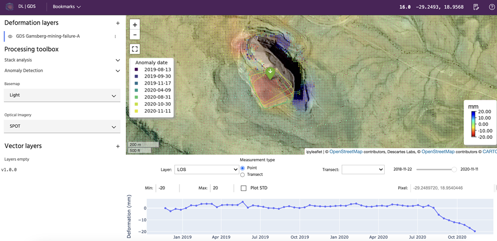
Validate, Organize, & Merge Data

Streamline and expand open source data management and avoid data redundancies with advanced infrastructure that acquires, validates, transforms, and loads OSINT feeds as a trusted tipping source.

Streamlined & Scalable Analytics

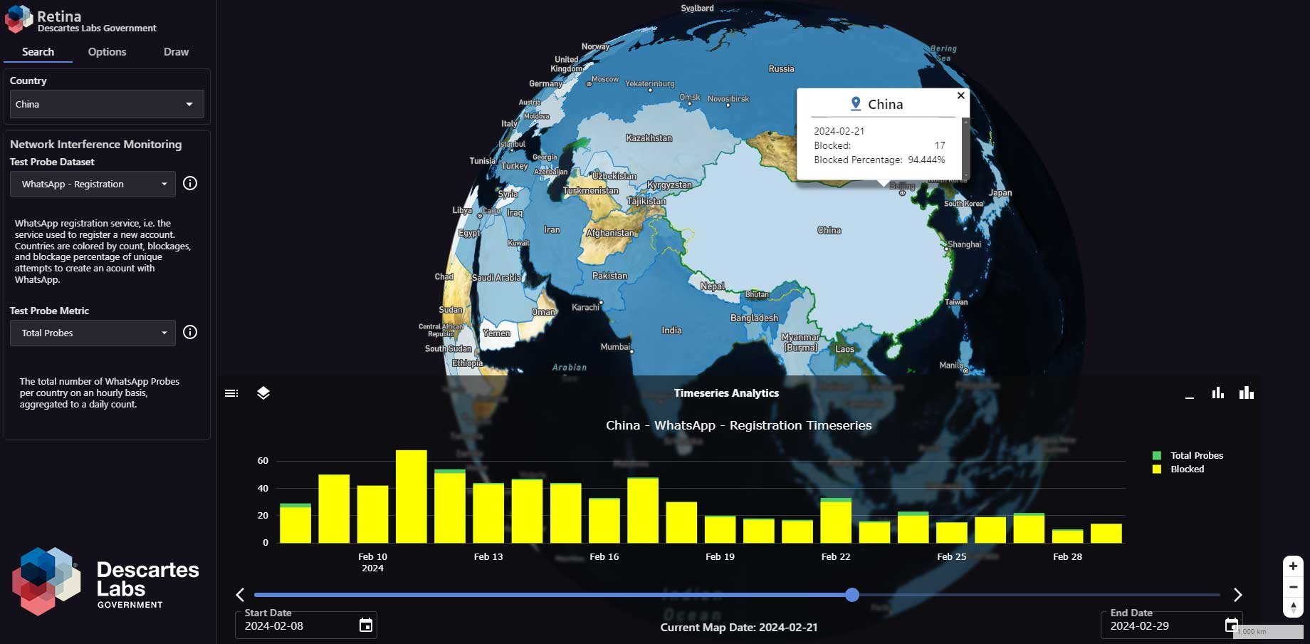
State-of-the-art user interfaces allow for the expansion of open source data integration, experimentation with operational functionality, and development of OSINT-based spatio-temporal Pattern of Life data.

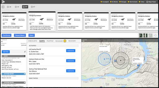
Automated, Near-Real Time Insights

Capitalize on established AI/ML commercial analytic models to rapidly innovate, test, and deploy new OSINT tools and tradecraft, and deliver timely insights to stakeholders at speed and scale.

Retina

See the world in real-time clarity


Retina (Rapid Exploitation Through Interactive Analysis) is an innovative solution that integrates Open Source Intelligence (OSINT) and Geospatial Intelligence (GEOINT) for rapid intelligence extraction, enabling government agencies to see the world in real-time clarity through a single, streamlined interface. 

DLG_Retina_UI
Retina interface
DL_Gamsberg Deformation_small
Gamsberg Deformation as seen through Iris 

Iris

Protect critical infrastructure


Iris (formerly known as GDS) is an InSAR-based deformation monitoring solution used to  continuously monitor critical infrastructure for signs of deformation and provides fast alerting for improved response to these anomalies.

  • New! Quicklook alerts show persistence of anomalies
  • Easy to use, no code interface enables users to easily and visually monitor AOIs
  • InSAR capabilities (i.e. ground deformation and velocity layer)

WayFinder

Reduce emergency response times by 25-50%


WayFinder is a mission management tool designed to aid Search and Rescue (SAR) operations by shortening the time between emergency beacon detection and responders hitting the ground.  

WayFinder enables SAR controllers to quickly ingest, assign, review, and coordinate SAR incident responses from any location, reducing triage times to a matter of minutes in the critical early moments of an emergency. WayFinder can be used as an alternative to manually intensive processes for triaging distress calls, localizing the source, prioritizing immediacy, and engaging local jurisdictions for response resources.

Modernize your SAR operations by leveraging critical response data and geospatial information in an actionable, resilient, and collaborative interface.

WayFinder interface

Incident screen co-locates all the resources a SAR controller needs to investigate and document potential incidents as well as manage ongoing missions. 


Prisma SWIR Data over Cuprite
Prisma SWIR data over Cuprite as seen through Marigold

Marigold

The most advanced remote sensing tool


Marigold is an all-in-one mineral exploration toolkit with advanced analytics for resource management. Rapid spectral processing can be used for operations and safety monitoring, and mine site reclamation efforts.

Now with hyperspectral processing capabilities, Marigold is the pinnacle of mineral exploration and enables users to evaluate more areas of interests (AOIs), faster, and over larger areas. Globally scalable, harness the power of Marigold with proprietary Bare Earth Composites—data layers that expose the optimum regional-scale imagery with the lowest vegetation, snow, cloud, ice and water possible to maximize surface rock exposure.

Let's Talk

Want a demo or have questions on how our solutions can help reach your mission objectives?